The Balkan Loop (2 Weeks): Croatia–Bosnia–Montenegro–Albania–N. Macedonia

Blog

The Balkan Loop (2 Weeks): Croatia–Bos...

The Balkan Loop (2 Weeks): Croatia–Bosnia–Montenegro–Albania–N. Macedonia

30 Oct 2025

The Balkan Loop (2 Weeks): Croatia–Bosnia–Montenegro–Albania–N. Macedonia

Planning a balkan itinerary 2 weeks long? This coastal-meets-mountains loop threads together Croatia’s polished Adriatic, Bosnia and Herzegovina’s Ottoman charm, Montenegro’s fjord-like bays, Albania’s wild Riviera and North Macedonia’s lake country. It’s compact enough for buses, richer with a rental car, and rewarding either way. Expect sea days, winding alpine passes, and one or two ferries if you want them. Connectivity varies: coastal corridors are strong, but inland national parks and ferry crossings can be patchy—so a smart eSIM plan and a quick APN check at each border will keep you online.

This guide gives you a day-by-day route with realistic travel times, the best side trips, and connectivity tactics that work in the Western Balkans (where “EU roaming” often doesn’t). We’ll show you when to stay coastal, when to go inland, bus vs car trade‑offs, and how to choose between a regional eSIM and stacking country eSIMs. Finish in Skopje (open-jaw) or loop back if you must—either way, you’ll cover the highlights without rushing.

Who this route suits (and when to go)

  • Best for: First-time visitors who want both Adriatic coast and inland culture, photographers, food lovers.
  • Trip style: 2 weeks, 1–3 nights per stop, mix of city and nature.
  • Transport: Works by bus; a car unlocks national parks and short ferries (Bay of Kotor shuttle, Komani Lake).
  • When: May–June and September–October for lighter crowds and steady ferry timetables. July–August is hot and busy; winter reduces services in mountain areas.

Open-jaw (start in Croatia, end in North Macedonia) saves backtracking. If you need a loop, see the variant at the end of this section.

Day 1–2: Dubrovnik, Croatia (arrival)

  • Why: Walk the city walls, Old Town, Elaphiti Islands ferry day.
  • Transport in: Fly to Dubrovnik; 25–40 minutes to town.
  • Ferry option: Half-day to Lopud or Koločep. Connectivity at sea is variable; download offline maps.
  • Connectivity note: Croatia is EU, but neighbouring legs aren’t—plan your eSIM accordingly (see below).

Day 3: Dubrovnik → Mostar, Bosnia and Herzegovina

  • Travel: 3–4 hours by bus; 2.5–3.5 hours driving (border timing varies).
  • Do: Old Bridge (Stari Most), Kujundžiluk bazaar at dusk.
  • Coverage: Good in town; dips in the mountains en route.

Day 4–5: Mostar → Sarajevo

  • Travel: 2–2.5 hours by train (scenic Neretva valley) or 2 hours by road.
  • Do: Baščaršija, Latin Bridge, Tunnel of Hope.
  • Inland vs coastal: This is your richest inland cultural stop—worth two nights.

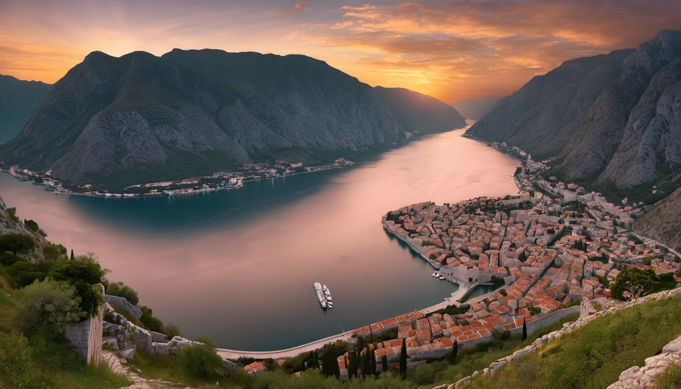
Day 6: Sarajevo → Kotor, Montenegro

  • Travel: 5.5–7.5 hours by bus; 5–6.5 hours by car via Trebinje. Border can add 30–90 minutes in season.
  • Do: Sunset from Kotor Fortress; Perast in the evening.
  • Ferry: If driving the bay, use the short Kotor Bay ferry (Lepetane–Kamenari) to save 30–45 minutes.
  • Coverage: Strong around the bay; occasional gaps on mountain approach.

Day 7: Kotor/Perast day

  • Pick one: Boat to Our Lady of the Rocks; drive to Lovćen National Park for switchback views.
  • Connectivity: Fine on the coast; Lovćen viewpoints can be spotty.

Day 8: Kotor → Budva → Lake Skadar (overnight near Virpazar) or Ulcinj

  • Travel: 1 hour to Budva; 1.5–2 hours to Virpazar; 2 hours to Ulcinj.
  • Do: Old Budva quick stop; Lake Skadar boat tour for birds and vineyards; or beach time in Ulcinj.
  • Inland vs coastal: Skadar is inland nature; Ulcinj keeps you coastal.

Day 9: Montenegro → Shkodër → Tirana, Albania

  • Travel: 3–5 hours total (border varies); roads are improving but watch speeds and signage.
  • Do: Rozafa Castle in Shkodër (lunch), then on to Tirana’s cafes and Blloku.
  • Coverage: Solid on the SH1 corridor; occasional drops near the border.

Day 10: Tirana → Berat or Gjirokastër (UNESCO)

  • Travel: 2–3 hours to Berat; 3.5–4 hours to Gjirokastër.
  • Pick one: Berat for vineyards and Ottoman quarters; Gjirokastër for stone-town drama and Blue Eye access.

Day 11: Riviera or Komani ferry (choose coast or inland)

  • Coastal day: From Gjirokastër, continue to the Albanian Riviera (Himarë/Dhermi). Beaches and cliff roads, but mobile coverage is mostly coastal.
  • Inland ferry: From Shkodër/Koman, the Lake Komani ferry is a standout day trip. Signal is minimal on the lake—download everything first.

Day 12: Albania → Ohrid, North Macedonia

  • Travel: From Tirana/Berat via Elbasan: 3.5–5 hours depending on border. From the Riviera, allow 6–7.5 hours.
  • Do: Lake Ohrid, old town, Saint Naum monastery (border-hop is possible by boat; carry ID).
  • Coverage: Good in towns, weaker on lakeside drives.

Day 13–14: Ohrid → Skopje

  • Travel: 3–3.5 hours by bus or car via Kičevo.
  • Do: Old Bazaar, Kale Fortress, Matka Canyon (half-day trip; patchy coverage inside the gorge).
  • Fly out from Skopje.

Need a closed loop?

  • Option A (fast): From Skopje, overnight bus/train back to Sarajevo (8–10 hours), then bus to Dubrovnik (4–6 hours). Adds one long transit day.
  • Option B (drive): Skopje → Sarajevo (7–9 hours), Sarajevo → Dubrovnik (4–6 hours). One extra night en route recommended.

Getting around: buses vs car, borders and ferries

  • Buses: Reliable, cheap, and frequent on main corridors (Dubrovnik–Mostar–Sarajevo; Kotor–Shkodër–Tirana; Tirana–Ohrid–Skopje). Buy tickets at stations or reputable sites; carry small cash for baggage fees.
  • Car rental: More freedom for national parks (Lovćen, Durmitor if you extend, Lake Skadar) and the Komani or Kotor ferries. Confirm cross-border permissions and insurance (“Green Card”) with your rental company before pickup.
  • Driving style: Coastal E-roads are straightforward; inland passes are narrow and slow. Plan daylight drives for scenery and safety.
  • Ferries you’ll actually use:
  • Bay of Kotor shuttle (Lepetane–Kamenari): 10 minutes, frequent.
  • Komani (Albania): Pre-book in high season; very limited signal on board.
  • Adriatic island day trips (Dubrovnik to Elaphiti; optional Split if you add it): Good service, variable signal offshore.

Connectivity: the smart way to stay online across five countries

EU-style roaming rarely covers this whole route. Croatia is EU; Bosnia and Herzegovina, Montenegro, Albania and North Macedonia are not in the EU/EEA. That’s why you should plan your connectivity up front.

Regional eSIM vs country eSIMs

  • Regional eSIM (ideal if available for “Balkans”): One plan, one APN, no SIM swaps. Check coverage includes all five: Croatia, Bosnia and Herzegovina, Montenegro, Albania, North Macedonia.
  • EU-only regional eSIMs (e.g., Esim Western Europe) typically exclude most of this route. They’re great if you’re adding Italy or Spain, but you’ll still need coverage for the non‑EU legs.
  • Country eSIM stack: Buy smaller data packs per country and activate as you cross borders. Slightly more admin, but often the most cost‑efficient if you use lots of data in one place (e.g., week in Albania).

Before you decide, check each country’s page under Destinations to confirm networks and 4G/5G availability.

APN checks at every border (2-minute routine)

  • Before crossing: Turn off data roaming on your eSIM to avoid out‑of‑bundle usage.
  • After crossing: 1) Toggle aeroplane mode on/off. 2) Manually select a local partner network if auto-connect fails. 3) Confirm APN matches the eSIM’s instructions. If blank/wrong, enter it manually. 4) Turn data roaming back on for that eSIM profile. 5) If data is slow, try 4G/LTE only (some rural towers are 4G-only).
  • Keep SMS from your eSIM provider handy; they often list the correct APN and preferred networks.

Coastal vs inland coverage (what to expect)

  • Coastal corridors: Dubrovnik–Herceg Novi–Kotor–Budva and the Albanian SH8 (Riviera) have solid coverage, with brief dead spots through tunnels and cliffs.
  • Inland/mountain parks: Expect patchy or no service on sections near Lovćen viewpoints, Durmitor (if detouring), parts of Lake Skadar, Komani ferry, Mavrovo/Matka canyons.
  • Cities and lakes: Dubrovnik, Sarajevo, Kotor, Tirana, Ohrid and Skopje have strong 4G; 5G is spotty and mainly urban—don’t rely on it between towns.

Ferry days: how to stay connected

  • Download offline maps (Google Maps/Organic Maps) and tickets/QR codes the night before.
  • Message contacts your departure/arrival windows early. Onboard Wi‑Fi is rare; tethering from patchy mobile signal isn’t reliable.
  • Queue screenshots: hotel address, driving directions for the first 30 km after the ferry, and key phrases in local languages.

If you’re pairing regions

  • Starting or finishing in Italy or Spain? Add a short EU eSIM like Esim Italy or Esim Spain alongside your Balkans plan.
  • Flying in via Paris or elsewhere in the EU? An EU pack such as Esim Western Europe covers your transit—but confirm where EU coverage ends before you head east.
  • Coming from the States or Canada? Get connected before you board with Esim United States or a transregional option like Esim North America, then switch to your Balkan plan on arrival.

Pre-trip checklist (connectivity-first)

  • Check country coverage and partner networks: Destinations.
  • Decide: Regional Balkans eSIM vs stacking country eSIMs.
  • Install eSIMs on Wi‑Fi at home; label profiles by country.
  • Note APN settings and preferred partner networks for each plan.
  • Download offline maps for each stop, plus bus tickets and hotel details.
  • Pack: Dual‑SIM phone or eSIM-capable device; power bank; universal adapter (Type C/F common; Type G in some hotels).
  • If renting a car: Confirm cross-border permission and roadside assistance numbers; download routes for mountain drives.

Pro tips: - Keep WhatsApp/Signal tied to your main number; data‑only eSIMs won’t receive normal SMS. - If you work on the road, schedule uploads when you’re in cities; rural uplink speeds can be slow. - Set data limits or use OS data saver to stretch smaller country packs.

Costs and time savers

  • Buses: 10–35 EUR per leg; buy in advance on busy routes.
  • Fuel and tolls: Coastal E-roads have fewer tolls than inland motorways; Montenegro and Albania rely on standard highways.
  • Accommodation: Coastal towns spike in July–August; book Kotor/Ohrid early.
  • Cash vs cards: Cards widely accepted in cities; carry small cash for buses, markets, and border snacks.
  • Data: City cafés have reliable Wi‑Fi; don’t bank on it in villages or on ferries.

FAQ

1) Is two weeks enough for this route? - Yes for highlights: Dubrovnik, Mostar, Sarajevo, Kotor, Tirana plus Berat or Gjirokastër, Ohrid, Skopje. Add a day if you want both the Komani ferry and the Albanian Riviera.

2) Bus or car—what’s better? - Buses are simple and cheap on the main corridors. Rent a car if you value flexibility for national parks, early starts, and short ferries (Kotor Bay, Komani). Avoid night driving on mountain roads.

3) Will my EU eSIM roam across this route? - Not fully. Croatia is EU; Bosnia and Herzegovina, Montenegro, Albania and North Macedonia are not. You’ll need a regional plan that explicitly lists these countries or separate country eSIMs. Verify coverage under Destinations.

4) Do I need to change APN settings at each border? - Often, yes. After crossing, toggle aeroplane mode, check you’ve connected to a partner network, and confirm the APN. If speeds are poor, set your device to 4G/LTE only and retry.

5) How reliable is coverage on ferries and in the mountains? - Ferries (Elaphiti, Komani) and canyon drives (Matka, parts of Lovćen/Skadar) can have little to no signal. Download offline maps and tickets beforehand; message contacts before departure.

6) I’m travelling for work—anything extra to consider? - Bring a backup data option (secondary country eSIM or hotel Wi‑Fi plan) and schedule calls from cities for stable bandwidth. If you’re organising a team trip, see Simology For Business. Travel companies and resellers can explore the Partner Hub.

Next step

Compare coverage and pick your regional or country plans for each stop via Simology’s Destinations. Install before you fly, note the APNs, and you’re ready for a smooth two‑week Balkan loop.

© Simology

// Make external links open in a new tab for (const a of document.querySelectorAll('#content a[href]')) { try { const u = new URL(a.getAttribute('href'), window.location.href); if (u.origin !== window.location.origin) a.setAttribute('target','_blank'); } catch(e) { /* ignore */ } } // Add 'lead' class to the first paragraph for nicer intro const firstP = document.querySelector('#content p'); if (firstP) firstP.classList.add('lead'); 

Read more blogs

Andes Highlights (3 Weeks): Peru–Bolivia–Chile–Argentina Connectivity

Andes Highlights (3 Weeks): Peru–Bolivia–Chile–Argentina Connectivity

Planning a south america itinerary 3 weeks through the high Andes? This route stitches together Peru’s Sacred Valley, Bolivia’s La Paz and Salar de Uyuni, Chile’s Atacama Desert, and northern Argentina’s quebradas or Mendoza wine country—often by long-distance bus and a couple of short flights. Connectivity is different at altitude: coverage is strong in cities but drops in high passes and salt flats; bus Wi‑Fi is patchy; border towns can be blackspots. The smart move is an eSIM with multi‑country coverage, backed by offline maps, offline translations, and a simple routine for crossing borders by bus without losing service. Below you’ll find a practical, connectivity-first itinerary; checklists to prep your phone, apps and documents; and on-the-ground tips for staying online where it matters: booking transport, hailing taxis, backing up photos, and navigating when the signal disappears.If you’re transiting via Europe or North America, you can also add a layover eSIM to stay connected door-to-door. Start with our country list on Destinations, then follow the steps, and you won’t waste time chasing SIM shops at 3,500 metres.The 3‑week Andes route at a glanceWeek 1: Peru (Cusco, Sacred Valley, Machu Picchu) - Fly into Cusco (or Lima then connect). - Base in Cusco; day trips to Pisac/Chinchero/Maras–Moray. - Train to Aguas Calientes; Machu Picchu visit; return to Cusco or continue to Puno/Lake Titicaca.Week 2: Bolivia and Chile (La Paz, Uyuni, San Pedro de Atacama) - Bus/collectivo via Copacabana to La Paz. - Fly or overnight bus to Uyuni. - 3‑day Uyuni–altiplano tour ending in San Pedro de Atacama (Chile).Week 3: Chile and Argentina (Atacama to Salta or Mendoza/Buenos Aires) - Choose: - North: San Pedro to Salta/Jujuy by bus; fly to Buenos Aires. - Or South: San Pedro–Calama flight to Santiago; bus or flight to Mendoza; onward to Buenos Aires.Connectivity notes (quick): - Cities: generally strong 4G/4G+; 5G in major hubs (Santiago, Buenos Aires). - Altitude/rural: expect long no‑signal stretches (Uyuni, altiplano passes, Paso Jama). - Bus Wi‑Fi: often advertised, rarely reliable. Plan to be offline onboard. - Border regions: networks switch; a multi‑country eSIM avoids sudden loss.eSIM vs local SIMs for a 4‑country tripFor a route with multiple borders and remote legs, eSIM wins on time and reliability.What a multi‑country eSIM gets you: - One plan across Peru, Bolivia, Chile, Argentina (check coverage per country on Destinations). - No passport/SIM registration queues at kiosks. - Keep your home number active on the physical SIM for calls/SMS codes. - Instant top‑ups if you burn data on photos or navigation.When a local SIM still helps: - Long stay in one country with heavy data use (e.g., a month in Buenos Aires). - Dead zones where a different local network performs better (rarely worth the hassle on a 3‑week pace).Practical approach: - Use an eSIM as your primary data line across all four countries. - If you find a specific local network far better in one region, add a cheap local SIM and keep the eSIM as backup.Device readiness checklist (before you fly)1) Check eSIM compatibility and SIM‑lock status on your phone.2) Buy and install your eSIM while on home Wi‑Fi. Keep a PDF/printed copy of the QR code.3) Label lines clearly (e.g., “eSIM Andes Data”, “Home SIM”).4) Turn on data roaming for the eSIM; leave roaming off for your home SIM to avoid charges.5) Set up dual‑SIM rules: data on eSIM; calls/SMS default to home SIM if needed.6) Download offline: Google Maps/Organic Maps for all target regions; language packs (Spanish at minimum); bus/air tickets; hotel confirmations.7) Cloud backups: set to upload on Wi‑Fi only; pre‑create shared albums for travel companions.8) Test tethering/hotspot with your laptop/tablet.If you’re transiting popular hubs, consider a short layover eSIM: - USA connections: add an Esim United States or a broader Esim North America.- Europe connections: Madrid/Barcelona? Use an Esim Spain. Paris or Rome? See Esim France and Esim Italy. Multi‑country layovers? Try Esim Western Europe.City‑by‑city connectivity notesCusco & the Sacred Valley (Peru)Coverage: Good in Cusco city; variable in high villages (Maras/Moray) and along Inca Trail approaches.Tips: Download Sacred Valley maps offline; pin viewpoints and ruins. most taxis use WhatsApp—save your accommodation’s number.Machu Picchu/Aguas Calientes: Patchy to none at the citadel. Upload your photos later; don’t rely on live ticket retrieval.Lake Titicaca: Puno and CopacabanaPuno: Reasonable 4G; bus terminals crowded—screenshot QR tickets.Crossing to Copacabana: Expect a signal drop around the border; have directions saved offline.La Paz (Bolivia)Good urban 4G; the cable car network has decent signal but tunnels do not.Yungas/“Death Road” tours: Mountain valleys cause dead zones—share your emergency contacts with the operator, carry a charged power bank, and don’t plan remote calls.Uyuni and the Altiplano (Bolivia to Chile)Uyuni town: OK 4G; ATMs finicky—use Wi‑Fi for banking apps.Salt flats/lagunas: Assume offline for most of the 3‑day tour. Guides often carry satellite phones; agree a pickup time/place in San Pedro and preload your map route.San Pedro de Atacama (Chile)Town: Solid 4G; accommodations often have Wi‑Fi but speeds vary.Geysers, Valle de la Luna: Offline navigation essential; sunrise trips start before mobile networks wake up in some areas.Salta/Jujuy or Mendoza/Buenos Aires (Argentina)Salta/Jujuy: Good city coverage; quebradas have long no‑signal sections.Mendoza: City 4G/5G; vineyards outside town can be patchy.Buenos Aires: Strong 4G/5G; ideal for cloud backups and large downloads before you fly home.Border crossings by bus: step‑by‑stepThe big ones on this route: Peru–Bolivia (Puno/Copacabana), Bolivia–Chile (Uyuni–San Pedro via Hito Cajón), Chile–Argentina (Paso Jama to Salta or Los Libertadores to Mendoza).How to keep service and sanity:1) The day before:- Top up your eSIM data.- Confirm your plan includes both countries you’re entering/leaving.- Download offline maps for both sides of the border and your town of arrival.- Save bus company WhatsApp and terminal address offline.2) On departure morning:- Keep a paper copy or offline PDF of tickets, insurance, and accommodation proof.- Charge phone and power bank; pack a short cable in your daypack.3) On the bus:- Don’t count on bus Wi‑Fi. Keep your eSIM as primary, but expect drops near mountain passes.- If your phone supports it, enable “Wi‑Fi calling” for later when you reach accommodation Wi‑Fi.4) At the border posts:- Data may be unavailable. Keep QR codes and booking numbers offline.- After exiting one country and entering the next, toggle Airplane Mode off/on to re‑register on the new network.- If the eSIM doesn’t attach, manually select a network in Mobile Settings.5) Arrival:- Send your accommodation a quick WhatsApp when you’re back online.- Recheck your eSIM’s data roaming is on; confirm you’re on an in‑country network, not a weak roaming partner.Pro tips: - Dual profiles: If your eSIM allows, keep a secondary profile for a different network in the same country—helpful in border towns.- Cash buffer: Some border terminals don’t accept cards; download a currency converter for offline use.Offline survival kit (5‑minute setup)Maps: Download regions for Cusco, Sacred Valley, Puno, La Paz, Uyuni, San Pedro, Salta/Jujuy or Mendoza, and Buenos Aires.Translations: Download Spanish for offline use; add phrasebook favourites (bus tickets, directions, dietary needs).Documents: Save PDFs of passports, tickets, hotel addresses; star them for quick access.Rides: Screenshots of pickup points; pin bus terminals and hotel doors.Entertainment: Podcasts and playlists for long bus legs, set to download on Wi‑Fi only.Altitude and your tech: what changesCoverage gaps lengthen: Fewer towers at high altitude; valleys can block signal. Assume offline on remote excursions.Batteries drain faster in cold: Keep your phone warm and carry a power bank (10,000–20,000 mAh).Hotel Wi‑Fi may be congested: Schedule big uploads (photo backups, app updates) for big-city stays like Santiago or Buenos Aires.GPS still works offline: Your blue dot shows on offline maps without data—preload everything.Data budgeting for 3 weeksTypical traveller usage across this route: - Messaging/Maps/Bookings: 0.2–0.5 GB/day- Social and photo sharing: 0.3–0.7 GB/day- Occasional video calls/streaming: 0.5–1.0 GB/dayFor a mixed-use trip, plan 15–25 GB for 3 weeks. Heavy creators should double it and upload over hotel Wi‑Fi when possible. If you work remotely, consider a higher‑capacity plan and a backup eSIM; see our guidance on For Business.Practical route with transport and connectivity cuesDays 1–4 Cusco base: Strong city signal; day trips may be spotty—go offline-ready.Days 5–6 Machu Picchu: Expect no service at the ruins; sync tickets ahead.Days 7–8 Puno to La Paz via Copacabana: Border signal drop; re‑register networks after crossing.Days 9–11 Uyuni tour to San Pedro: Treat as offline; charge nightly; carry spare cables.Days 12–14 San Pedro: Stable in town; tours offline; top up data before Paso Jama.Days 15–17 Salta/Jujuy or Mendoza: Good urban 4G; rural patches are offline.Days 18–21 Buenos Aires: Strongest connectivity of the trip; clear your uploads and map downloads for the flight home.Partnering and stopover extrasHospitality and tour operators in the Andes: help your guests stay connected—explore co‑branded solutions via our Partner Hub.Transatlantic flyers: test your eSIM setup on a layover with an Esim United States or Esim Western Europe before hitting high-altitude blackspots.FAQs1) Do I need a local SIM in each country?No. A multi‑country eSIM covering Peru, Bolivia, Chile and Argentina is simpler and works well for a 3‑week pace. Consider a local SIM only if you’ll spend longer in one country and want the absolute best regional coverage.2) Will my WhatsApp number change with an eSIM?No. WhatsApp is tied to your registered number, not your data line. Keep your home SIM active for voice/SMS (roaming off if you wish), and use the eSIM for data—WhatsApp continues as normal.3) Can I hotspot to my laptop or camera?Yes. Enable tethering on your eSIM. Mind your data: cloud backups and OS updates can burn gigabytes—set them to Wi‑Fi only or schedule in big cities.4) What if there’s no signal on the Uyuni/Atacama legs?That’s expected. GPS still works offline. Pre-download maps and translations, carry a power bank, and sync plans with your tour operator before departure.5) Will I get roaming charges at borders?If you’re using a multi‑country eSIM with coverage in both countries, you won’t incur extra roaming fees from your home carrier. Keep roaming off on your home SIM to avoid accidental use.6) I’m connecting via Europe or the US—worth getting a layover eSIM?Yes. It’s an easy way to test your setup and stay reachable. Try Esim North America or country options like Esim Spain, Esim France, or Esim Italy for common hubs.Next step: Browse South America coverage options and build your plan on Destinations.

Coverage Map Tools: OpenSignal, CellMapper, nPerf — How to Read Them

Coverage Map Tools: OpenSignal, CellMapper, nPerf — How to Read Them

Planning connectivity for a trip shouldn’t be guesswork. Operator marketing maps can be optimistic, while your phone’s signal bars tell you very little about what you’ll actually get at a hotel, train station or hiking trail. Crowdsourced tools—OpenSignal, CellMapper and nPerf—fill the gap, if you know how to read them. This guide explains what each tool shows, how to interpret the RSRP/RSRQ/SINR overlays that really matter for 4G/5G, and the caveats (crowdsourced bias, indoor realities, device limits) that can trip up travellers. You’ll learn a simple, repeatable method to compare carriers for your route, decide between regional eSIMs, and sanity‑check 5G claims before you land. We also flag pitfalls like rural gaps, mmWave mirages and time‑of‑day effects. If you need destination‑specific tips and plans, explore our country pages via Destinations; region bundles such as Esim Western Europe and Esim North America can simplify choices.Coverage vs signal vs capacity: a 60‑second primerCoverage means the network’s radio signal reliably reaches you.Signal quality determines whether that connection is robust enough to carry data without errors.Capacity is how much traffic the cell can handle; it governs download speeds at busy times.Carrier maps often show “service footprint” (coverage) but not quality or capacity. Crowdsourced tools add the layers that matter: actual signal strength and quality measurements, speed tests, and observed cell sites.The key radio metrics you’ll seeFor 4G/5G, three metrics tell most of the story:RSRP (Reference Signal Received Power): the “strength” of the LTE/NR reference signal.Typical interpretation:Excellent: −65 to −85 dBmUsable: −85 to −100 dBmMarginal: −100 to −110 dBmPoor/unreliable: below −110 dBmRSRQ (Reference Signal Received Quality): quality of the reference signal relative to noise/interference.Good: −3 to −9 dBFair: −10 to −15 dBPoor: below −15 dBSINR (Signal‑to‑Interference‑plus‑Noise Ratio): how clean the signal is.Excellent: > 20 dBGood: 13–20 dBFair: 0–13 dBBad: < 0 dB (expect drops/timeouts)Rule of thumb: RSRP tells you if you can connect; SINR/RSRQ predicts whether it will be stable and fast. In cities, interference (SINR) often limits performance more than raw signal strength.The tools at a glanceOpenSignalWhat it is: Aggregated, crowdsourced performance maps and operator comparisons.Shows: Average download/upload, 4G/5G availability, experience by operator, heatmaps.Strengths: Easy operator‑to‑operator comparison; good for “typical user experience.”Limits: Less tower‑level detail; can smooth over micro‑dead zones and indoor issues.CellMapperWhat it is: Community‑mapped cell sites and sectors with band/technology info.Shows: Estimated tower locations, sectors, EARFCNs/NR ARFCNs (bands), and user‑logged RSRP/RSRQ.Strengths: Deep technical view; great for understanding which bands/tiles cover specific streets or buildings.Limits: Coverage depends on where contributors travelled; maps can be patchy or out of date in low‑traffic areas.nPerfWhat it is: Speed‑test platform with crowdsourced coverage/performance overlays.Shows: Speeds, latency, browsing/streaming scores, 2G/3G/4G/5G layers.Strengths: Clear performance heatmaps; good at visualising capacity hotspots and slow zones.Limits: Heavily biased toward areas where people run tests; may overrepresent urban corridors.Use them together: OpenSignal for broad operator comparison, nPerf for performance reality, CellMapper to validate tower/band layers and indoor likelihood.Step‑by‑step: check coverage for your trip1) Outline your connectivity needs- Pin key locations: airport, hotel, workspace, stadiums, rural stops, mountain passes.- Note indoor priorities: basement co‑working, thick‑walled historic hotels, conference centres.- Decide must‑haves: stable video calls, tethering, unlimited messaging, or sheer coverage.2) Shortlist operators and eSIMs- Use Destinations to see local network options and traveller notes.- For regional travel, compare Esim Western Europe and Esim North America; for single‑country trips, see Esim United States, Esim France, Esim Italy or Esim Spain.3) OpenSignal: compare operators along your route- Search your city/region; toggle operators.- Check 4G/5G availability and download speed layers, zooming into your hotel and work sites.- Identify the top two operators for the areas you’ll spend the most time.4) nPerf: sanity‑check performance hotspots- View the download/latency heatmaps for those operators.- Look for “cold” pockets in otherwise “hot” districts—often indoor problem areas or congested cells.- Note any sharp performance drop on your commute route or in tourist zones at peak times.5) CellMapper: validate tower positions and band layers- Select the same operator and technology (LTE/NR).- Find the nearest cells to your hotel/workspace; check sector directions and band IDs.- Look for low‑band (e.g., LTE Band 20/12/13; 5G n28) for indoor reach, and mid‑band (LTE B3/B7; 5G n78/n41) for speed.- If your device lacks a band shown as dominant, that operator may underperform for you.6) Decide: pick the best fit eSIM- Prefer operators with consistent RSRP better than −100 dBm and SINR consistently above ~10 dB at your key spots.- If one operator excels in cities but you’ll road‑trip, prioritise the one with better rural low‑band footprint.- Choose a plan that lets you switch if needed mid‑trip (dual‑eSIM or top‑ups help).7) Before you go: field‑test checklist- Install the apps (allow location), save offline map areas if supported.- Note backup operator options in case your first choice underdelivers.- For business‑critical travel, consider a primary plus a backup eSIM; see For Business for multi‑user or team needs.Pro tip: If you’re a creator, agent or host recommending connectivity to guests, our Partner Hub provides resources and benefits.Reading RSRP/RSRQ/SINR overlays like a proHeatmap colours: Apps use their own scales, but focus on the numeric ranges when available. A −90 dBm RSRP with 18 dB SINR is typically better than −80 dBm with 2 dB SINR in a noisy city.4G vs 5G labels: 5G NSA often relies on 4G anchors. If CellMapper shows strong mid‑band LTE but spotty 5G NR, your speeds may mirror LTE at busy times.mmWave mirages: Dense, block‑level 5G icons can indicate mmWave (n260/n261). Expect great speeds line‑of‑sight outdoors, little to no indoor reach, and tiny coverage footprints.Low‑band for reach: Bands like LTE B20 (800 MHz), B12/13 (700 MHz) and NR n28 penetrate buildings and cover rural stretches. Don’t expect top speeds, but they keep you online.Mid‑band for capacity: LTE B3/B7 (1800/2600 MHz) and NR n78/n41 (3–3.7 GHz) bring faster data; indoors they depend on building materials and distance to the cell.If you’re new to these concepts, skim our broader network explainers for background on bands, NSA/SA and propagation basics.Real‑world caveats: crowdsourced bias and indoor realitiesCrowdsourced maps are immensely useful, but they reflect where people go and what devices they carry.Biases and blind spots to account for: - Urban skew: City centres are well‑mapped; remote trails and rural villages may have little data. “No colour” can mean “no tests,” not “no coverage.”- Drive‑test bias: Highways are over‑represented; residential backstreets and parks may be under‑sampled.- Device mix: Newer phones support more bands and 5G features. If most local testers carry flagships, your older handset may perform worse than the map suggests.- Time of day: Congestion spikes in tourist zones and at rush hour; performance heatmaps can hide daily swings.- Permissions and OS quirks: If users deny precise location, cell placements and measurements may be fuzzed.- Version lag: Operators re‑farm bands and add sites; community updates take time to reflect changes.Indoor caveats: - Materials matter: Concrete, foil‑backed insulation, low‑E glass and underground venues can slash RSRP by 20–30 dB and tank SINR.- Wi‑Fi offload: Speed tests on hotel Wi‑Fi can skew app heatmaps near venues; cross‑check with cell metrics.- Building geometry: A cell “behind” your building’s thick core might leave your meeting room in a dead spot even if the lobby is fine.Pro tips: - Cross‑verify at least two tools for each critical location.- Look for low‑band presence on CellMapper near indoor venues; if absent, expect indoor issues.- Prefer operators with multiple nearby sectors (diversity improves resilience).- If you rely on tethering, check nPerf latency as well as throughput; stable sub‑50 ms latency beats bursty high peaks.Practical use cases and how to approach themCity break with remote work: Prioritise SINR and nPerf latency near your accommodation and co‑working space. A mid‑band‑rich operator with clean SINR typically beats a “wider coverage” rival for Zoom.Alpine or coastal drives: Look for continuous low‑band coverage along the route; check CellMapper for cells facing valleys or shorelines. Keep a backup eSIM if there are known gaps.Stadiums/conventions: Expect congestion. Favour operators showing mid‑band/5G layers with nearby small cells; test crowd periods if possible. Carry offline maps and tickets.Cross‑border rail: Regional eSIMs like Esim Western Europe simplify roaming handovers; verify coverage for each leg using local operators on OpenSignal.US national parks: Use Esim United States and check low‑band LTE coverage on CellMapper; don’t assume 5G availability implies usable service inside canyons or forests.Quick checklist: on the groundIn settings, enable 4G/5G auto and VoLTE/VoNR where available.If data is flaky indoors, try forcing LTE (5G NSA can sometimes underperform with poor anchors).Move a few metres or nearer a window; SINR can jump dramatically with small position changes.Toggle airplane mode to reselect a better cell/anchor after a move.If speeds collapse at peak times, try another operator if you carry a backup eSIM.FAQ1) Which app is “most accurate”?No single app. Use OpenSignal to compare operators, nPerf to visualise real performance, and CellMapper to verify towers and bands. Agreement across two of the three is a strong signal you can trust.2) How do RSRP/RSRQ/SINR translate to real‑world performance?- RSRP better than −100 dBm usually means usable connectivity.- SINR above ~10 dB supports stable browsing and HD calls; above ~20 dB you’ll typically see top speeds for the band.- Poor RSRQ (worse than −15 dB) hints at congestion/interference—expect variability.3) Why does the map say 5G but my phone is slow?5G NSA may anchor on a weak 4G cell, or you might be on low‑band 5G with good reach but modest capacity. Indoor losses and congestion also apply. Check SINR/RSRQ and band layers on CellMapper.4) Can these tools predict indoor coverage?Indirectly. Look for nearby low‑band cells and strong outdoor RSRP. Thick walls, metal and underground levels can still kill signal; plan a backup (Wi‑Fi calling or a second operator).5) Do I need a regional or country eSIM?If you cross borders, regional plans reduce friction. See Esim Western Europe and Esim North America. Single‑country trips can use Esim France, Esim Italy or Esim Spain.6) I travel for work—any special advice?Carry two eSIMs on different networks, prioritise SINR/latency near meeting venues, and pre‑test video calls. Our team plans on For Business simplify multi‑user management, with partner options via the Partner Hub.Next step: Map your route and shortlist networks with the steps above, then choose an eSIM on Destinations to lock in reliable coverage before you fly.

UK & Ireland in 10 Days: London–Edinburgh–Dublin–Ring of Kerry

UK & Ireland in 10 Days: London–Edinburgh–Dublin–Ring of Kerry

Planning a UK–Ireland circuit in 10 days is absolutely doable if you keep travel handoffs clean and your mobile connectivity sorted. This route prioritises fast intercity links and two bucket-list rural days so you’re not stuck in transit. You’ll start in London, ride the rails to Edinburgh, hop to Dublin by air (or ferry if you prefer), then road-trip the Ring of Kerry from a Killarney base. With a single regional eSIM, you can cross borders without swapping plastic SIMs, keep your home number live for iMessage/WhatsApp, and stay online even when the Highlands or the Dingle Peninsula thin out to a few bars of 4G.Below is a practical, step-by-step plan with timings, booking tips, and connectivity guidance. If you’re extending to mainland Europe or coming from North America, we’ve flagged the simplest eSIM and transport options to avoid roaming bill-shock and wasted hours.At a glance: your 10-day UK–Ireland itineraryDay 1: Arrive London (stay 3 nights)Day 2: London highlightsDay 3: London neighbourhoods or day tripDay 4: Train to Edinburgh (stay 2 nights)Day 5: Edinburgh Old Town + Arthur’s Seat/LeithDay 6: Fly (or ferry combo) to Dublin (stay 2 nights)Day 7: Dublin city essentialsDay 8: Train to Killarney (stay 2 nights)Day 9: Ring of Kerry loopDay 10: Return to Dublin or depart from ShannonPro tip: Book an open-jaw flight (into London, out of Dublin/Shannon). It saves a backtrack day.Transport handoffs you won’t regretLondon → Edinburgh (rail, ~4h 20m)Best option: LNER fast trains from London King’s Cross to Edinburgh Waverley.Book early for low fares; pick a direct service and a table seat with power sockets.Travel light—UK intercity trains have overhead racks and small luggage stacks.Pro tip: Bring snacks. Onboard trolleys run out on busy trains.Edinburgh → Dublin (1h flight or ferry+train combo)Easiest: Direct flight (about 1 hour). Edinburgh Airport is close; the Tram or Airlink bus is simple.Alternative (scenic, longer): Train/bus to Cairnryan, ferry to Belfast, then the Enterprise train to Dublin (expect 7–9 hours end-to-end). This works best if you want a Belfast stopover.When to pick the ferry: If you dislike flying or want to avoid bag fees. Otherwise, fly.Dublin → Killarney (train ~3–3.5h)Heuston Station to Killarney on Irish Rail (often 1 change at Mallow).Book seats; bring a packed lunch. Killarney station is walkable to many hotels.Ring of Kerry (self-drive or small-group tour)Drive counter-clockwise from Killarney to sync with coach flow (reduces passing on narrow stretches).No car? Choose a small-group tour (better photo stops and less time at souvenir traps).Killarney → Dublin or ShannonTo Dublin: Train back to Heuston (~3–3.5h).From the west: Shannon Airport is 2 hours by car; allow extra time for car return.Connectivity: eSIM vs physical SIM across bordersA single regional eSIM is the cleanest solution for this itinerary—no queues, no swaps, no roaming roulette.Use a regional plan: See Esim Western Europe for UK and Ireland coverage in one profile. It avoids SIM swaps when you cross the Irish Sea.Why eSIM over physical SIM: Instant delivery via QR code, keep your home SIM active for calls/SMS 2FA, and switch data lines per country if needed.Network expectations:UK cities (London, Edinburgh): Strong 4G/5G on major networks; underground Wi‑Fi in London; patchier coverage inside some stone buildings.Ireland cities (Dublin, Killarney): Good 4G/5G in towns; some 3G/4G drops on rural stretches of the Ring of Kerry.Highlands/Kerry backroads: Expect occasional dead zones; download offline maps in advance.If you’re continuing to Europe, add-on or switch to regional plans for nearby countries: Esim France, Esim Italy, or Esim Spain. Coming from North America? Set up before you fly with Esim United States or Esim North America for the journey to/from the UK and Ireland.Quick setup checklist (5 minutes)Buy and install: Purchase your plan (e.g., Esim Western Europe) and scan the QR code over Wi‑Fi.Set data line: On your phone, set the eSIM as the default for mobile data. Keep your physical SIM for calls/SMS if needed.iMessage/FaceTime:iPhone: Settings > Messages > Send & Receive. Tick your Apple ID and your preferred number. If your home SIM receives SMS OTPs, keep it active for voice/SMS but set the eSIM for data.Turn off “Send as SMS” to avoid your home carrier charging when data blips occur.WhatsApp:If you want your home number intact, do nothing—WhatsApp will keep using it even with a different data eSIM.If you need a new number, use Change Number in WhatsApp settings; notify contacts automatically.Offline maps: Download Google Maps areas for London, Edinburgh, Dublin, and County Kerry; save key addresses (hotels, stations, car hire).Hotspot needs: Check plan hotspot allowance if you’ll tether a laptop on trains.Pro tip: Add local transport apps over Wi‑Fi before you go. London: Citymapper, TfL Go. Dublin: TFI Live. Irish Rail and LNER apps for tickets and live platform info.Day-by-day highlights and time saversDays 1–3: LondonEssentials: Westminster/Big Ben, South Bank walk, Tower of London, St Paul’s, Borough Market, British Museum, Covent Garden.Time-savers:Use contactless bank cards/phone for Tube and bus—no need for an Oyster card.Group nearby sights: Tower Bridge, Tower of London, Borough Market in one loop.Book one ticketed highlight in advance (e.g., Sky Garden, Westminster Abbey) and keep the rest flexible.Connectivity note: Great 5G outdoors; Tube has patchy signal between stations. Download tickets/wallet passes before you descend.Day 4–6: EdinburghDay 4: Scenic LNER ride; check in near the Royal Mile or New Town for walkability.Day 5: Edinburgh Castle, Royal Mile closes, National Museum (free), sunset from Calton Hill or Arthur’s Seat if weather cooperates.Day 6 morning: Dean Village and Stockbridge; lunch in Leith if you have time.Connectivity note: Good coverage in town. If you take a half-day Highlands tour, expect occasional dropouts—download playlists and maps.Day 6–8: DublinFly Edinburgh → Dublin. Airport bus to city (return tickets are good value); taxis and rideshares are regulated and straightforward.Day 7: Trinity College/Book of Kells, Grafton Street, St Stephen’s Green, Kilmainham Gaol (book), Guinness Storehouse (sunset slot at Gravity Bar).Evening: Live music in a pub off the main Temple Bar strip for a less touristy feel (try Camden Street or Rathmines).Connectivity note: Airport and city have strong 4G/5G. Museum interiors may dampen signal—keep tickets offline.Day 8–10: Killarney and the Ring of KerryDay 8: Train to Killarney; rent a car in town or confirm your small-group tour pickup.Day 9: Ring of Kerry loop:Killarney → Killorglin → Cahersiveen → Waterville → Sneem → Kenmare → Molls Gap → Killarney.Add Skellig Ring (weather/season permitting) for standout views; be mindful of narrow roads.Day 10: Morning in Killarney National Park (Muckross House, Torc Waterfall) before your onward train or drive.Connectivity note: 4G pockets with rural gaps. Save offline maps and key stops; cache music for the drive.Pro tip: If you’re nervous about left-side driving, book an automatic car and verify excess cover. Small-group tours remove the parking stress and let you focus on scenery.Money, time and stress saversRail bookings: Reserve seats on LNER and Irish Rail; pick window seats with power. Off-peak can be significantly cheaper.Airports vs ferries: For this route, the Edinburgh–Dublin flight wins for time. Ferries suit those who dislike flying or plan a Belfast stop.Contactless everywhere: Cards/phones tap for almost all transport and small purchases in both countries.Sundays and bank holidays: Reduced train frequencies; book earlier/later departures to avoid crush loads.Driving the Ring: Start early to beat coaches; fuel up the evening before.Coverage realities in rural UK & IrelandExpect signal fades on:A82/A87 (if detouring into the Highlands)Skellig Ring spurs and parts of Iveragh PeninsulaMitigations:Download offline areas and route pins.Enable Wi‑Fi Calling at your hotel for crisp calls.Keep “Low Data Mode” off if you’re relying on live navigation traffic reroutes.If you’re planning more destinations, browse coverage notes for each country on Destinations.Business and group travellersRemote work: Trains have mixed Wi‑Fi; use your eSIM hotspot where coverage is strong. Book accommodation with guaranteed desk space and reliable Wi‑Fi.Teams: Centralised purchasing and usage oversight are available via For Business.Tour operators/agents: Streamline client connectivity or bundle data with your trips through our Partner Hub.Packing and powerPlugs: UK and Ireland use Type G, 230V. Bring a quality adapter with built-in USB-C.In-car: A 12V charger and a sturdy cable for mapping. Windscreen mounts are useful on Kerry’s bends.Weather: Layers and a compact waterproof; shoes with grip for wet cobbles and viewpoints.FAQDo I need a car for the Ring of Kerry?No, but it helps. Small-group tours are an excellent stress-free alternative and avoid parking headaches.Flight or ferry between Scotland and Ireland?For this itinerary, fly Edinburgh–Dublin (about 1 hour). Ferries work if you want a Belfast stop or dislike flying, but take most of a day end-to-end.Will one eSIM work in both the UK and Ireland?Yes—choose a regional plan like Esim Western Europe to cover both without swapping SIMs.Will iMessage or WhatsApp break when I switch to an eSIM?No. Keep your home SIM active for SMS/voice, set the eSIM for data, and confirm iMessage’s Send & Receive settings. WhatsApp continues on your existing number unless you choose Change Number.How bad is rural coverage on the Ring of Kerry?Mostly fine on main roads with occasional dead zones. Download offline maps and cache playlists; you’ll regain 4G in towns like Kenmare, Sneem, and Cahersiveen.I’m extending to mainland Europe—do I need a new plan?Possibly not. Check the footprint of your regional plan. You can add or switch to country plans like Esim France, Esim Italy, or Esim Spain if needed.Next stepSet up your cross-border data before you fly. Pick a regional plan for both countries on Esim Western Europe, and browse country specifics on Destinations.